An earthquake is a sudden shaking or trembling of the ground, often caused by the movement of tectonic plates beneath the Earth’s surface. It can result in the displacement of buildings, landslides, and tsunamis, causing significant damage and loss of life.
In recent years, seismic activity has been closely monitored and studied to better understand the patterns and potential risks associated with earthquakes. Scientists and seismologists use various instruments to measure and analyze seismic waves, providing crucial information for emergency preparedness and the development of resilient infrastructure in earthquake-prone areas.
With advancements in technology and research, efforts are being made to enhance early warning systems and improve our ability to predict and mitigate the impact of earthquakes on communities and infrastructure.
Formation And Fault Lines
Understanding the formation and fault lines of earthquakes is essential for comprehending the science behind these powerful natural occurrences. Earthquakes are the result of tectonic shifts in the Earth’s crust, which can lead to the release of immense energy that causes the ground to shake.
Understanding Tectonic Shifts
Tectonic shifts refer to the movement of large sections of the Earth’s crust, called tectonic plates. These plates are constantly moving, albeit at a very slow rate, and they interact with each other at their boundaries. The boundaries between tectonic plates are the primary areas where earthquakes are born.
The Earth’s lithosphere, which is composed of the crust and the uppermost portion of the mantle, is divided into several tectonic plates. There are seven major plates, including the African Plate, Antarctic Plate, Eurasian Plate, Indo-Australian Plate, North American Plate, Pacific Plate, and South American Plate, along with numerous smaller plates.
The Role Of Stress Accumulation
Stress accumulation plays a crucial role in the occurrence of earthquakes. As the tectonic plates interact with each other, they become locked together due to friction along their boundaries. This locking creates stress on the rocks, causing them to deform and store potential energy.
Over time, the stress continues to accumulate until it reaches a critical point. When the stress overcomes the frictional forces holding the rocks together, it is released in the form of an earthquake. The energy is transferred through the Earth’s crust in the form of seismic waves, resulting in the shaking of the ground.
The accumulation of stress is not a linear process and can vary in different regions. The magnitude of an earthquake depends on factors such as the amount of stress accumulated, the extent of the fault line affected, and the specific characteristics of the rocks involved.
Recognizing Foreshocks
Foreshocks are smaller earthquakes that occur before a larger mainshock event. Although not all earthquakes have foreshocks, they can be an indication that a larger earthquake is imminent. Monitoring and recognizing foreshocks can help seismologists and authorities issue timely warnings and take necessary precautions to minimize the potential impact of the impending mainshock.
Foreshocks typically occur along the same fault line as the mainshock but with lower magnitudes. While their occurrence cannot accurately predict the exact timing or magnitude of a mainshock, they serve as a valuable tool in earthquake forecasting and preparedness.
Understanding the formation and fault lines of earthquakes, along with the role of stress accumulation and recognizing foreshocks, provides valuable insights into the science of earthquakes. By studying and monitoring these phenomena, scientists and researchers strive to improve our understanding of seismic events and enhance our ability to mitigate their impact on human lives and infrastructure.
Identifying Precursors
Earthquakes, one of the most intense natural disasters, can strike suddenly and have devastating consequences. However, scientists have made significant progress in identifying precursors that can hint at an impending earthquake. By analyzing various factors, such as crustal movements and seismic waves, along with the advancements in monitoring technology, we can now gain valuable insights into the likelihood of an earthquake.
Earth’s Crustal Movements
The Earth’s crust consists of several tectonic plates that are constantly in motion. These movements can sometimes result in stress accumulation along the plate boundaries, leading to earthquakes. By closely monitoring and studying the crustal movements, scientists can detect any unusual patterns or changes that may indicate an increased seismic activity in a particular region.
One way to measure crustal movements is through the use of Global Positioning System (GPS) technology. GPS stations placed strategically along fault lines provide real-time data on the displacement and deformation of the Earth’s crust. Analyzing this data helps scientists identify any anomalies that could be an indication of an earthquake precursor.
Seismic Waves As Early Warning Signs
Seismic waves, which are propagating vibrations caused by earthquakes, can provide valuable information about the nature and magnitude of an impending earthquake. By studying the characteristics of these waves, scientists can identify early warning signs that indicate the likelihood of a future seismic event.
Primary waves (P-waves), which travel faster than other types of seismic waves, are often the first to be detected during an earthquake. These waves can serve as an early warning sign by indicating the initial rupture of the fault, giving people a few seconds to seek shelter. Similarly, the arrival time and amplitude of secondary waves (S-waves) can provide further insights into the severity of an earthquake.
Monitoring Technology Advancements
The advancements in monitoring technology have revolutionized our understanding of earthquakes and their precursors. Seismographs, devices designed to measure and record ground motions caused by seismic waves, have evolved significantly over time. Modern seismographs equipped with advanced sensors and data processing capabilities allow scientists to accurately capture and analyze even the smallest seismic events.
In addition to seismographs, various remote sensing techniques, such as satellite imaging and radar interferometry, offer valuable information about the Earth’s surface deformations. These technologies enable scientists to monitor large areas and detect subtle changes in the topography that could indicate the buildup of stress along fault lines.
Furthermore, the development of early warning systems, like the ShakeAlert system in the United States, utilizes real-time seismic data to provide timely warnings to affected regions. These advancements in monitoring technology have significantly improved our ability to identify earthquake precursors and enhance preparedness efforts.
In conclusion, by closely monitoring Earth’s crustal movements, analyzing seismic waves as early warning signs, and leveraging advancements in monitoring technology, scientists can identify precursors that hint at an impending earthquake. These insights provide crucial information for disaster preparedness and response efforts, allowing communities to better protect themselves and minimize the potential damage caused by earthquakes.
Earthquake : Shaking The Foundations: Severity Scale
Earthquakes are natural disasters that can cause immense destruction and pose a serious threat to human life and infrastructure. The severity of an earthquake is determined by various factors, including its magnitude and intensity. By understanding these measurements, we can better quantify the destruction caused by earthquakes and develop effective disaster management strategies.
Measuring Magnitudes And Intensities
Measuring the magnitude and intensity of an earthquake is essential in comprehending its impact. Magnitude refers to the total energy released by an earthquake, while intensity indicates the level of shaking experienced at a particular location. The Richter Scale and the Modified Mercalli Intensity (MMI) Scale are commonly used to measure these aspects.
Quantifying Destruction
Quantifying the destruction caused by an earthquake is crucial for assessing the scale of the disaster and guiding relief efforts. While magnitude provides an overall measure of the earthquake’s power, it does not directly convey the damage caused. The MMI Scale, on the other hand, offers a more detailed assessment by considering the effects on structures, people, and the environment.
The MMI Scale ranges from I (not felt) to XII (total destruction), with each level describing specific observed effects. These effects encompass everything from slight vibrations (level I) to catastrophic destruction (level XII). By evaluating the MMI level at different locations, seismologists can determine the extent of damage and prioritize rescue and recovery operations.
The Infamous Richter Scale
The Richter Scale is a logarithmic scale invented by Charles F. Richter in 1935. It measures the amplitude of seismic waves generated by an earthquake. The scale ranges from 0 to 10, with each whole number increase representing a tenfold increase in amplitude and roughly 31.6 times more energy released.
While the Richter Scale is widely recognized, it does have limitations. It is most accurate for earthquakes with magnitudes between 3 and 7 and loses accuracy beyond that range. Additionally, the scale measures only the amplitude of seismic waves, not the actual damage caused.
To address these limitations, other magnitude scales like the Moment Magnitude Scale (Mw) have been developed. The Mw scale incorporates data from various types of seismic waves and provides a more accurate estimate of the earthquake’s total energy release.
A comprehensive understanding of the severity of an earthquake is essential for planning emergency responses, implementing building codes, and designing earthquake-resistant structures. By considering both the magnitude and intensity of earthquakes, along with their associated scales, we gain valuable insights into the destructive potential of these natural phenomena.
Impacts On Urban Landscapes
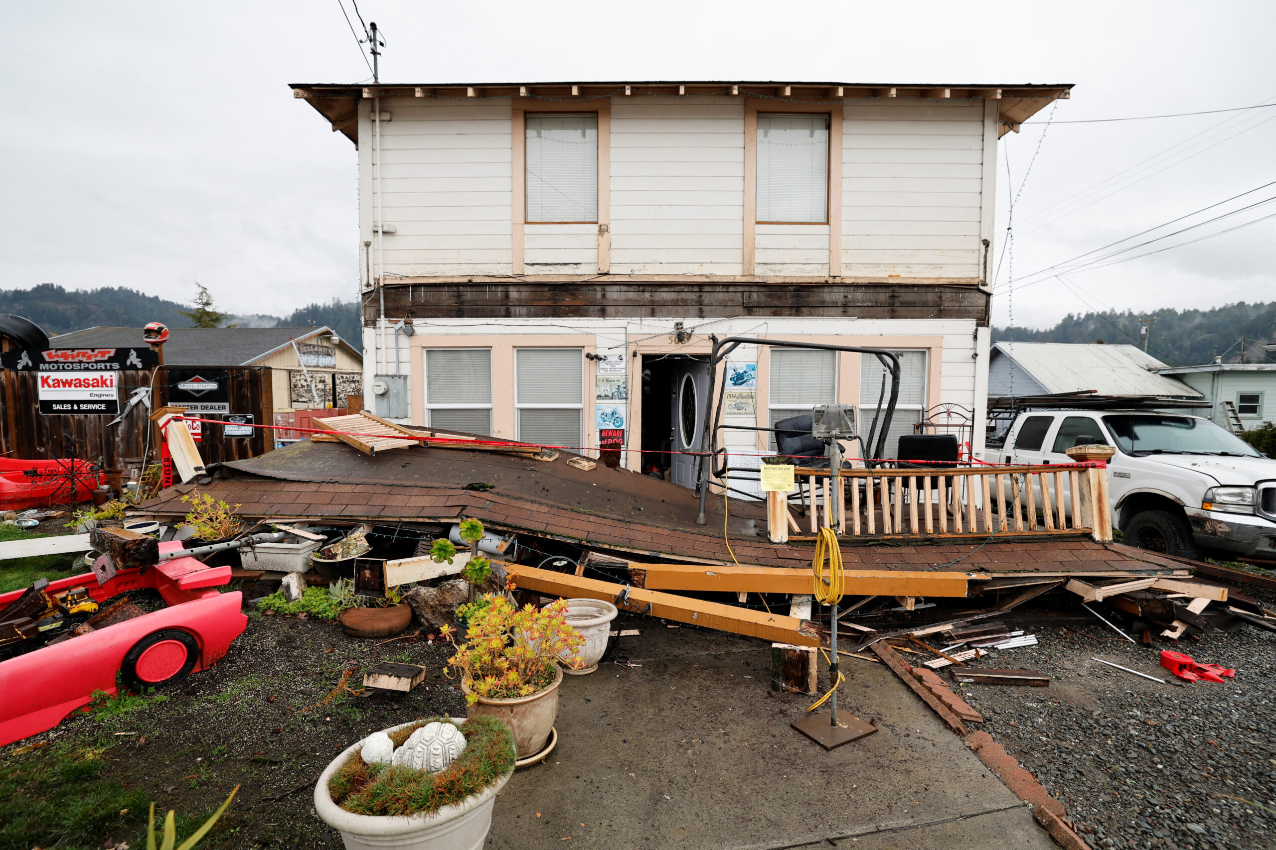
Earthquakes can have significant impacts on urban landscapes. These natural disasters can cause extensive damage to buildings, infrastructure, and roads, leading to widespread destruction and disruption in affected areas.
Structural Failures And Collapses
When an earthquake strikes, urban landscapes can suffer devastating consequences. One of the most concerning impacts is the occurrence of structural failures and collapses. Buildings that are not constructed to withstand the powerful forces unleashed by an earthquake can crumble, endangering the lives of those inside and causing significant damage to the surrounding areas.
In densely populated cities, the risk of structural failures is even higher, as old and poorly maintained buildings coexist with newer constructions. The lack of seismic retrofitting in older structures amplifies the vulnerability, making them more susceptible to collapsing during an earthquake.
- Disruption of essential services, such as electricity, water, and gas, leading to further chaos and potential hazards.
- Blockage of roads and transportation routes due to debris, hindering rescue and relief efforts.
- Injuries or fatalities to individuals caught within the collapsing structures, requiring immediate medical attention and evacuation procedures.
Risks To Infrastructure
The impacts of earthquakes on urban landscapes extend beyond structural damages. The infrastructure that supports cities, such as bridges, roads, and utilities, is also at risk during seismic events. The strong ground shaking and ground rupture can destabilize these critical elements, initiating a chain reaction of failures.
- Bridges and overpasses can suffer structural damage, rendering them unsafe for use and disrupting transportation networks.
- Pipelines and underground utilities may rupture, leading to leaks, fires, or shortages of essential resources.
- Communication networks, including cell towers and cables, can be severely impacted, hampering emergency response efforts and isolating affected areas.
Note: Governments, engineers, and urban planners are continuously working to strengthen and improve the resilience of urban infrastructure to mitigate the risks posed by earthquakes. Innovative techniques and technologies, such as base isolation and advanced monitoring systems, are being employed to enhance the survivability of critical structures and systems.
Historical Earthquakes And Lessons Learned
Examining historical earthquakes provides valuable insights into their impacts and allows us to learn from past experiences. Previous earthquakes have served as catalysts for implementing safety measures and regulations to minimize future damages. By understanding the lessons learned, cities can become better prepared to withstand future seismic events.
Examples of historical earthquakes and the lessons they taught us:
| Earthquake | Lessons Learned |
|---|---|
| Great East Japan Earthquake (2011) |
|
| Loma Prieta Earthquake (1989) |
|
By analyzing these historical earthquakes, scientists, engineers, and policymakers constantly strive to improve seismic hazard assessments, emergency response systems, and urban planning strategies. The goal is to build cities that can withstand the brunt of future earthquakes, thereby minimizing the impacts on urban landscapes.
Building Earthquake-resistant Structures
The importance of constructing earthquake-resistant structures cannot be overstated. Earthquakes can have devastating consequences on buildings and human lives, making it essential to implement engineering innovations, adhere to regulations and building codes, and promote community-level preparedness.
Engineering Innovations
When it comes to building earthquake-resistant structures, engineering innovations play a crucial role in minimizing damage and protecting lives. Engineers have developed advanced techniques to reinforce buildings, such as:
- Base isolation systems: These systems absorb earthquake energy and reduce the impact on the structure. They involve installing flexible pads or bearings between the foundation and the building, allowing it to move more independently.
- Stronger materials: Utilizing high-strength materials like reinforced concrete and steel can enhance a building’s ability to withstand seismic forces.
- Damping devices: Devices like viscoelastic dampers or tuned mass dampers can be integrated into structures to dissipate seismic energy, reducing vibrations.
Regulations And Building Codes
Ensuring that structures are built to withstand earthquakes requires strict adherence to regulations and building codes. These essential guidelines provide the framework for designing and constructing earthquake-resistant buildings. Some key regulations and codes that engineers and builders follow include:
- International Building Code (IBC): The IBC sets forth standards for constructing buildings in earthquake-prone regions, including specific requirements for materials, structural systems, and seismic design criteria.
- National Earthquake Hazards Reduction Program (NEHRP): NEHRP provides guidelines to mitigate earthquake risks and improve the resilience of structures. It establishes performance-based design methodologies tailored to different levels of seismic hazard.
- Local building codes: Alongside national and international codes, local authorities may have additional requirements to address specific geological conditions, ensuring buildings can withstand localized seismic activities.
Community-level Preparedness
Building earthquake-resistant structures is only one aspect of minimizing the impact of earthquakes. Community-level preparedness is equally crucial to safeguard lives and facilitate effective response and recovery. Communities can take several measures to enhance their preparedness:
- Educational programs: Conducting educational programs and awareness campaigns can educate community members about earthquake risks, response protocols, and evacuation procedures.
- Emergency planning: Developing and regularly updating comprehensive emergency plans helps communities respond promptly and efficiently during earthquakes, ensuring the safety of residents.
- Collaboration with authorities: Establishing strong partnerships with local authorities, such as emergency management agencies, can facilitate timely communication and coordinated response efforts.
- Structural assessments: Regularly assessing structures within the community, including schools, hospitals, and infrastructure, ensures early identification of vulnerabilities and prompt retrofitting or repairs.
Uncovering The Devastating Power: Response And Recovery
When an earthquake strikes, the immediate focus shifts to responding to the immediate aftermath and initiating long-term recovery efforts. The devastating power of these natural disasters prompts the deployment of swift response protocols and the coordination of international aid and cooperation. In this article, we will delve into these critical aspects of earthquake response and recovery.
Immediate Response Protocols
Immediate response protocols are crucial in the aftermath of an earthquake. These protocols dictate a systematic approach to rescue operations, medical assistance, and relief distribution. First responders, including emergency personnel, search and rescue teams, and medical professionals, are mobilized to affected areas, working tirelessly to save lives and alleviate suffering.
Here are a few key components of immediate response protocols:
- Assessing damage and identifying areas of highest need.
- Rescuing individuals trapped in collapsed buildings or other dangerous situations.
- Providing medical aid and establishing temporary medical facilities.
- Distributing emergency supplies such as food, water, and shelter.
- Restoring essential services, such as electricity and communication systems.
Long-term Recovery Efforts
Following the initial response, attention shifts towards long-term recovery efforts aimed at rebuilding communities and infrastructure, developing sustainable solutions, and promoting resilience. Long-term recovery involves a comprehensive approach that address the physical, economic, social, and psychological aspects of the affected areas.
Here are some key focuses of long-term recovery efforts:
- Repairing and reconstructing damaged buildings and infrastructure.
- Providing support for displaced individuals and families.
- Revitalizing local economies through job creation and investment.
- Implementing measures to reduce future seismic risks.
- Supporting community development initiatives and social services.
International Aid And Cooperation
Earthquakes often require international aid and cooperation due to the scale of destruction and the urgent need for resources. Governments, non-governmental organizations (NGOs), and international bodies collaborate to provide assistance, share expertise, and coordinate relief efforts.
Here are a few examples of international aid and cooperation:
- International organizations like the United Nations and the Red Cross mobilize resources and provide funding for relief and recovery efforts.
- Countries unaffected by the earthquake offer financial assistance, humanitarian aid, and expertise.
- NGOs with specialized disaster response teams deploy personnel to support local efforts.
- Experienced organizations offer technical expertise in areas such as structural evaluation and seismic retrofitting.
Through international aid and cooperation, the global community comes together to support affected regions in their journey towards recovery and resilience.

Credit: www.nationalgeographic.com
Frequently Asked Questions On Earthquake
What Causes Earthquakes?
Earthquakes are caused by the sudden release of energy in the Earth’s crust, usually due to tectonic plate movement.
How Can Earthquakes Be Measured?
Seismologists measure earthquakes using instruments called seismographs, which detect and record the vibrations caused by seismic waves.
Can Earthquakes Be Predicted?
While scientists cannot predict earthquakes with certainty, they can use historical data and monitoring systems to assess the probability of future seismic activity.
Conclusion
Earthquakes are natural disasters that can cause immense destruction and loss of life. Understanding their causes and effects is crucial in order to mitigate their impact and protect vulnerable communities. By implementing proper preparedness and response measures, we can reduce the devastation caused by earthquakes and ensure the safety of our society.
Let’s strive towards building resilient infrastructure and raising awareness to create a more secure and sustainable future.